


brenon club

clintest
User
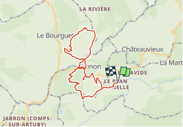

Length
19.5 km

Max alt
1256 m

Uphill gradient
869 m
Km-Effort
31 km

Min alt
818 m

Downhill gradient
868 m
Boucle
Yes
Creation date :
2024-01-11 07:31:53.268
Updated on :
2024-01-11 07:32:17.336
7h03
Difficulty : Difficult

FREE GPS app for hiking
 SityTrail
IGN / Geographical institutes
SityTrail Plus
The world is yours!
About
Trail On foot of 19.5 km to be discovered at Provence-Alpes-Côte d'Azur, Var, La Martre. This trail is proposed by clintest.
Positioning
Country:
France
Region :
Provence-Alpes-Côte d'Azur
Department/Province :
Var
Municipality :
La Martre
Location:
Unknown
Start:(Dec)
Start:(UTM)
303667 ; 4848259 (32T) N.
Comments